Groundwater Modeling

- State-of-the-art programs
- Accurate & Precise Modeling
- Simple & easy to understand mapping and representation
Eco makes use of burgeoning technology in order to transpose our field data into accurate groundwater models. Groundwater modeling helps the client better understand the groundwater by providing a visual map of below-the-surface wells and aquifers. Data collected on site using state of the art technology provides the most accurate GPS data available and efficiently translates that data into easily decipherable and distinct representative maps.
Associated Projects | |
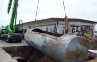 Removal of five 10,000 Gallon UST Los Alamitos, CA |
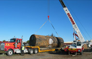 UST Removal Marysville Airfield Yuba County, California |
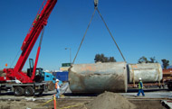 Removal of Multiple USTs City of Bell, CA |
|